Jenny Barry's Cave
Time – 45 minutes
Distance – 3 km/2 miles
A walk through a hidden valley along to a cave named after Jenny Barry, one of the two witches, or carlines, after whom Carlops is reputed to be named. The witches would jump between the two outcrops of rock in the village – ‘Carlin’s Loup’ or Carlops. According to local legend, lead was mined in Jenny Barry’s Cave in Mary, Queen of Scots time, the ore being exported to Holland where silver was extracted.
Route: Start/finish – Carlops
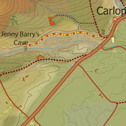
Leave the car park, bear left and cross the A702 and take the farm track up towards Carlopshill Farm (signposted ‘Buteland by the Borestane’). After 75m, you will reach a metal gate leading into the field to your left, with a map attached to the fence showing the route of this walk.
Pass through the gate and descend into the field, heading to its far end and to its top right corner, to pass through a gate into a second field. In this field, you will find an unusual row of hillocks, these being kaims left by glacial drainage, running along the middle of the valley. Pass to the left of the kaims, following a track round and through a fence and over a drainage ditch into a third field, now walking along the right hand side of the valley with the kaims to your left.
Near the end of this field, as you draw level with a kaim to your left with rocky outcrops on it flank, you will reach the cave, set into the side of the valley. The water issuing from the cave is the source of Carlops Burn.
This valley is ‘Windy Gowl’ which leads all the way up to the footpath from Stoneypath Farm to Baddinsgill. Unfortunately, there is no easy way of walking up the valley, the way being barred by various fences and marshy areas, so unless you feeling adventurous, you will have to retrace your steps back to the car park. You could add a little bit of variety by walking along the tops of the kaims

