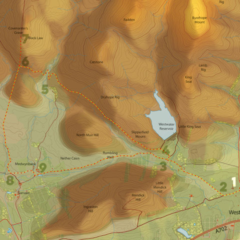
Covenanter's Grave
Time – 4-5 hours
Distance – 19km/11.5 miles
A long walk out to perhaps the loneliest, most remote and atmospheric spot in the Pentlands. Mostly on good, level tracks but with sections across rough and boggy moorland probably best done in dry and clear weather. The return leg follows the route of walk B6, ‘Prehistoric Walk to West Linton’, which is worth taking with you for its useful historical notes.
Route: Start/Finish – West Linton
![]()
Leave the village and cross the A702, turning up the minor road opposite St Mungo’s Church signposted to Baddinsgill. Head up the road for 1.5km then turn left towards West Linton Golf Club [1] (footpaths signposted to ‘Dolphinton, Dunsyre and Garvald’, and ‘Boston Cottage’).
Continue along the tarmac road leading across the golf course [2] for 1km to North Slipperfield. Passing through gates, the road crosses a bridge then heads uphill towards the West Water reservoir. Where the road bends right, ignore the first track signposted ‘Garvald and Dunsyre’ [3] (you’ll come back this way later), and continue uphill (signposted ‘Boston Cottage’), taking the track to the left after 50m [4]. The track continues uphill, with the reservoir dam wall visible up to your right, eventually levelling out and heading west.
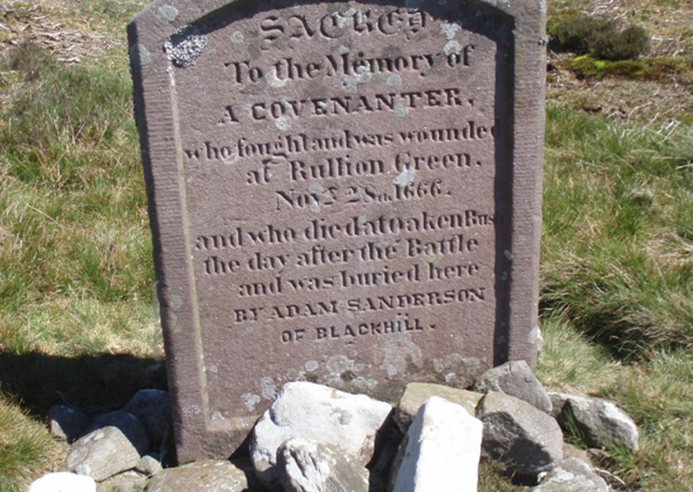
After 3km, the track dips down into the valley of Medwyn Water [5], crossing a bridge then heading uphill again. 750m later, you will reach a four way signpost on your right. Turn right off the track here [6] and follow the signpost ‘Crosswood via Covenanter’s Grave’, heading uphill across moorland. The path is not very clear on this section, but aim for the marker post on the horizon. Passing the first marker post, head for and pass the second. Shortly after this, you will reach the Covenanter’s Grave headstone [7], about 750m from the signpost.
The grave marks the resting place of a covenanter who had fled into the hills, trying to return home to Ayrshire after the battle of Rullion Green in Penicuik in 1666. Gravely wounded, he made it as far the house of a shepherd, Adam Sanderson, the ruins of which are still visible just south of the bridge over the Medwyn Water. Realising he was soon to die, he asked Sanderson to bury him within sight of the Ayrshire hills. Sanderson found him dead the next morning. At great risk to himself, Sanderson buried the covenanter near the summit of Black Law, from where the Ayrshire hills can indeed be seen on a clear day. This is a remote but beautiful spot.
Retrace your steps back to the track and continue straight over, this time following the signpost to ‘Dolphinton via Garvald’ over the moor. Once again, the path is unclear and followed by walking along the line of marker posts that heads south across the boggy ground.
After 2km, the moor gives way to grazing land and the path heads down into a gully and alongside a burn with some fine swimming pools. Pass through a gate along a clear path down to a signpost [8] close to a water pipeline.
Turn left here, signposted ‘Dolphinton and West Linton’, passing through a gate and then along a grassy track to Medwynbank. Pass through a gate onto a tarmac surface and over a small bridge, passing to the front of the house at Medwynbank, then turn left through gateposts with the house to your left and a pond to your right.
Just past the end of the pond, turn right onto a way-marked track [9] and head up a gentle slope with woods to your right. The undulating track then follows the route of walk B6, passing by several prehistoric burial cairns.
After 3.5km, the track emerges on the road between North Slipperfield and West Water reservoir that you walked up earlier. Turn right and head down to re-cross the golf course and then back down to West Linton