Kitchen Moss
Time – 3 to 4 hours
Distance – 15km/9 miles
A circular walk across high moorland that connects two trans-Pentland footpaths, with fine views to Edinburgh, the bridges, Fife and beyond, as well as views of the Pentland ridge that cannot be seen from anywhere else. The ‘official’ paths are good and well marked, but the section across the Moss has no path and covers rough moorland, boggy in places
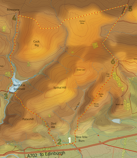
Route: Start/Finish – Ninemileburn
![]()
Park at the south end of Ninemileburn [1] in the area where the lane turns through 90 degrees. Walk along the lane south-west for a few hundred metres, then turn right along the track up to Spittal Farm [2] (signposted ‘Buteland via North Esk Reservoir’). Follow the track anti-clockwise around the back of the farm, climbing upwards. Continue steeply up the track to the saddle between Spittal Hill and Patie’s Hill. Pass through a gate to follow an estate track that follows the contour of the hill before dropping down towards the North Esk reservoir. Cross the dam wall and turn right just before the keeper’s cottage, following the sign to Buteland [3], walking along the side of the reservoir. Towards the end of the water, you pass a hide (the Dulverton Hide), which is a great place to stop for a rest and to watch the birdlife on the islands. Once past the reservoir, cross a stile, follow the Buteland sign again and continue for 3 km up to a gate and fingerpost (Buteland/Carlops) [4] near to the Borestane (ahead of you down to the left).
Go through the gate, turning right to follow the dry stane dyke for 4 km across Kitchen Moss. The route here is easy to follow, just stick to the wall, and surprisingly dry underfoot. About half away across, where the words ‘Kitchen Moss’ are printed on the OS map, the wall reaches a junction [5]. Cross the gate and turn right, following the wall heading north-east. Continue until you reach a gate and fingerpost on the Balerno-Ninemileburn ‘Red Path’ track.
Turn right through the gate and continue for 2km up to the saddle below West Kip. Turn right off the track here, crossing a stile to follow the sign for ‘Ninemileburn by Monk’s Rig’ [6]. The path climbs up and to the right of a plantation on the hillside, and then follows the ridge of Monk’s Rig, heading down towards Ninemileburn. The path passes by the Font Stone, the remains of an ancient stone cross base, where tossing a coin into the hollow is meant to bring good luck.Continue downhill, over one stile and then another, turning left to walk down the edge of a field. As you lose height, fingerposts will direct you through fields back down to Ninemileburn and your start point.
